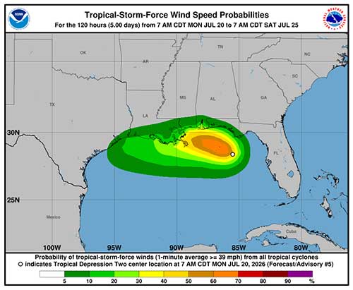
MIAMI — Forecasters at the National Hurricane Center (NHC) are closely monitoring Tropical Depression Two, which formed over the northeastern Gulf of America on Sunday and is expected to strengthen into Tropical Storm Bertha as early as Monday. The system, previously designated Invest 91L, brings the 2026 Atlantic hurricane season’s second named storm into focus, with potential impacts spanning the northern Gulf Coast from Florida to Texas later this week.
As of 8 a.m. EDT Monday, the depression was centered near 28.0°N, 85.3°W, approximately 155 miles south of Panama City, Florida. Maximum sustained winds were near 30 mph, with higher gusts. The system is moving slowly north-northwest at about 2 mph. Forecasters anticipate a continued slow northwestward or north-northwestward motion over the next day or two, followed by a turn toward the west. On this track, the depression is forecast to move near or along the northern Gulf Coast during the coming days.
Gradual strengthening is expected, and the depression is likely to become a tropical storm — named Bertha — tonight or Monday. A Tropical Storm Watch is in effect for the Florida Panhandle from the Ochlockonee River to the Alabama border, where tropical storm conditions are possible by late Monday. Additional watches or warnings could be issued as the system progresses.
Rainfall the Primary Threat
While wind impacts may remain relatively modest, heavy rainfall poses the greatest concern. The depression is expected to produce 2 to 4 inches of rain, with localized totals up to 6 to 8 inches, through Thursday along the eastern and central Gulf Coast from western Florida to southern Alabama, Mississippi, and Louisiana. Flash flooding will be a significant risk, particularly in urban and low-lying areas.
Coastal flooding and rough surf are also possible, with rip currents a hazard for beachgoers. Residents and visitors along the Gulf Coast are urged to clear storm drains, avoid driving through flooded roadways, and monitor local forecasts closely. Even a weak tropical system can produce dangerous localized flooding when moving slowly, as this one is expected to do.
Uncertain Track Adds to Challenges
The system’s slow movement and the presence of a high-pressure ridge to the northwest and a trough to the northeast introduce uncertainty into longer-range forecasts. If the depression stays farther south over warmer Gulf waters, it could strengthen more significantly. A track closer to the coast, however, would limit intensification due to land interaction and drier air.
Models show a general westward drift after initial northward movement, with possible landfall or close approach to portions of Louisiana, Mississippi, or eastern Texas by mid-to-late week. Impacts in South Mississippi, for example, could arrive Tuesday evening into Wednesday, depending on the exact path.
This marks the second tropical depression of the 2026 Atlantic season. The NHC continues to issue regular advisories, with public updates available through local National Weather Service offices and the NHC website.
Preparedness Reminders
Emergency management officials across the Gulf states are activating monitoring teams and reviewing evacuation and shelter plans. Residents should:
- Review family emergency plans and assemble or restock disaster supply kits.
- Secure outdoor objects and trim trees near structures.
- Heed any evacuation orders or advisories from local authorities.
- Stay informed via reliable sources, including NOAA Weather Radio and official apps.
While it is too early for precise landfall predictions, the system serves as an important reminder that hurricane season is well underway. The National Oceanic and Atmospheric Administration (NOAA) has forecasted an above-average 2026 season, with multiple named storms still expected.
The NHC will continue providing updates as Tropical Depression Two evolves. Forecasters emphasize that even systems that remain below hurricane strength can deliver significant rainfall and coastal hazards. Communities from the Florida Panhandle to coastal Texas should remain vigilant in the days ahead.